Follow on Facebook


RSS Feed


Follow on Twitter


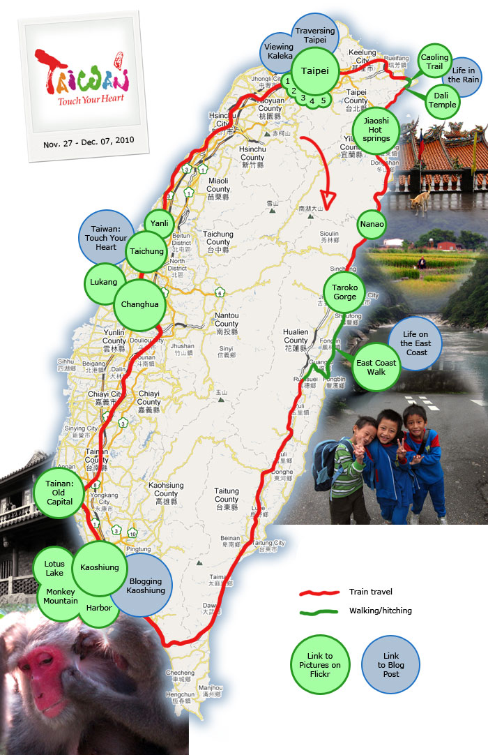
A little interactive map of our Taiwan journey. Click on green circles to go to the corresponding photo album on flickr; blue circles will take you to their corresponding blog post.

If you find this interactive visualization interesting or helpful, please leave a comment, so that I can better decide whether or not to make similar maps for future countries—thanks!

Viewing Kaleka in Taipei - Blog Post Traversing Taipei - Blog Post Taipei Highlights - Photos on Flickr Taipei Day 1 Taipei Day 2 Taipei Day 3 Taipei Day 4 Taipei Day 5 Jioashi to Nanao Photos Jioashi to Nanao Photos Caoling Trail Photos Dali Tiengong Temple Photos A Day in the Life... Camping in the Rain - Blog Post Taroko Gorge Photos Hualien to Taitung, East Coast Walk Photos A Day in the Life... on Taiwan's East Coast - Blog Post Kaohsiung Photos Kaohsiung - Blog Post Lotus Lake Photos Monkey Mountain Photos Kaohsiung Harbor Photos Tainan Photos Changhua Photos Lukang Photos Taichung Photos Taiwan: Touch Your Heart - Blog Post Sanyi Photos
Tags:

this is great dude. can

this is great dude. can follow you around with a map in my head, and quickly skip the parts that are not interesting to me, and jump to the ones that are. that dali temple is something i must visit.


Post new comment

Please use your real name if comfortable. Anonymous comments may be removed.
Your email address will be kept private and will not be shown publicly. Comments with fake email addresses may be removed.
  • Web page addresses and e-mail addresses turn into links automatically.
  • Allowed HTML tags: <a> <em> <strong> <cite> <code> <ul> <ol> <li> <dl> <dt> <dd>
  • Lines and paragraphs break automatically.
  • Adds typographic refinements.

More information about formatting options

By submitting this form, you accept the Mollom privacy policy.